Friday, 23 August 2013

Bude, Coast and Canal

On the South West Coast Path website this walk,  http://www.southwestcoastpath.com/walksdb/34/, starts in Bude, however it was more convenient for us to start at Widemouth Bay and walk in the opposite direction

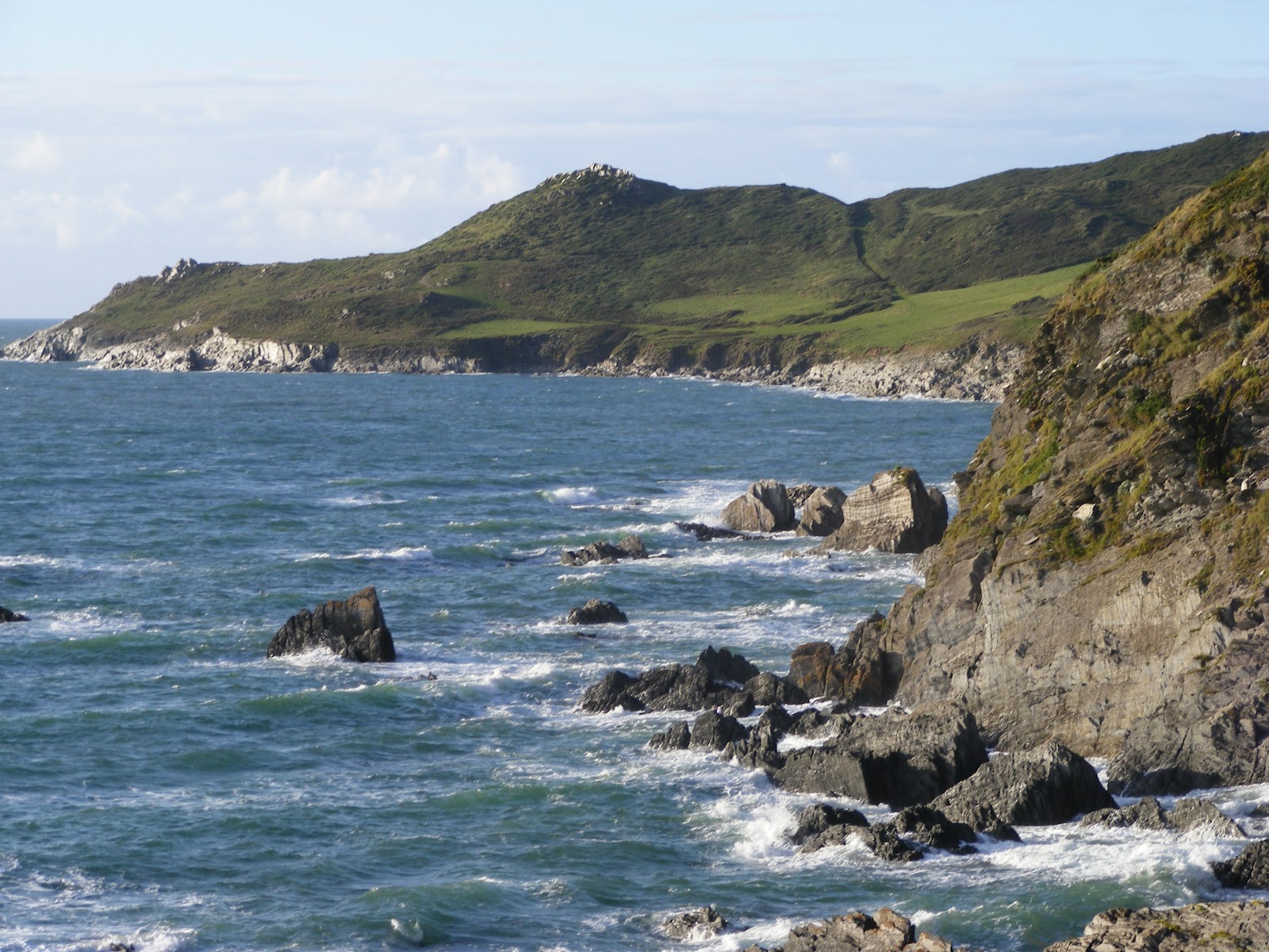
We anticipated that the car park by the beach at Widemouth would be expensive so drove past it to a car park on the cliff overlooking the beach.  We were very pleased when we got there to discover it was a free car park.  The car park led right on to the SW Coast Path and we were soon walking towards Bude.  The views were lovely, but probably been better it the tide had not been so low exposing all the rocks.  There was some heather and gorse in blossom on the cliff tops, but not as much as I had hoped.


The coast path was undulating, but there were not any really steep inclines.  Soon we were on the cliffs overlooking the beach at Bude, where we stopped for our lunch.


We proceeded to walk into Bude and crossed the canal to divert into the Heritage Centre which is situated in Bude Castle.  There was some lovely art work on display in the galleries here and the area around was attractively laid out gardens.  We were also impressed with the small craft shops along the edge of the canal.  After buying an icecream (and not been ripped off pricewise, which was refreshing) we started to walk along the towpath.  This was an excellent pathway and it was good to see people enjoying boating and canoeing along.  After passing a lock there were no more boats, and it was very tranquil.


After a couple of miles we came to Helebridge.  There was a large tea rooms here with activities for children, but we did not stop but headed across fields to return to Widemouth Bay.

This had been an excellent walk and one we would repeat again.

Wednesday, 14 August 2013

Hallsands to Lannicombe

It was high tide as we drove through Kingsbridge, which made this part of the journey very pretty.  But once we turned off the A379 the road was very narrow and windy which was not good for driving.  The last part to the Start Point lighthouse was particularly narrow with vegetation brushing the car as we drove past.  For such a remote car park we were surprised that we had to pay £3.50, but the views around Start Bay were spectacular and made it worthwhile.


To begin with we walked out to the Lighthouse, which was a concreted path.  We then retraced our steps to the South West coast path and followed this around the Point.  To begin with this was a rocky path and we had to be careful how we walked, but the views were superb.


As we walked we were amazed at the number of butterflies we saw.  Many of them were landing on the path in front in front of us.


This moth was dead on the path


As we approached Great Mattiscombe Sands the path improved and the walk from there to Lannicombe beach was relatively easy and fairly flat with only gradual short climbs.  The beach at Great Mattiscombe looked lovely with fine sand.  Lannicombe was more stoney, though we could see that as the tide went out there was sand.  There were only a few parking spaces at Lannicombe at the end of a track so I am glad that we did not drive there.  We had planned to turn around at Lannicombe, which was fortunate as there has been a landslide just past there and the footpath has a long diversion.

Initially we planned to walk across the fields from Lannicombe to Hallsands, but the coastal path was so scenic and such a good path we decided just to retrace our steps to Great Mattiscombe Sands.  We then took the direct path back to the car park, which was uphill, but a good path.

After a rest we then walked from the car park down to Hallsands. Again we had fantastic views around Start Bay all the way and loads of white butterflies fluttering around the fern on the bank at the side of the path. It was very interesting to see the information of the lost village of Hallsands on the viewing platform overlooking the village.


As we walked back we had the view of the Lighthouse.  Unfortunately it was quite a climb back to the car park, not particularly steep but a long climb that was not good at the end of a day's walk.  It would have been better if we had parked at Hallsands, which was free, and walked from there, and then the last part of the walk would have been downhill.

Saturday, 29 June 2013

Torcross to Hallsands

In the past we have walked from Starcross to Blackpool Sand along Start Bay.  Today was a lovely summer's day so we thought we would walk along more of Start Bay.

We drove to Beesands and were very impressed by this fishing village by the sea.  There were people fishing from the beach and boats in the bay.  Some fish were drying at the top of the beach.


We walked along the path at the top of the beach til the end and then climbed to walk to Torcross.  It was a steep climb, but the view half way up encouraged us to keep going.


After a while the path became steps and then levelled off before winding down to Torcross.  There were hedges both sides of the path and overhanging above it and unfortunately there were lots of insects flying around.

As we approached Torcross there were spectacular views along Slapton Sands.


Having taken a rest at Torcross we walked back to Beesands where we had fish and chips at the restaurant on the seafront.  You could taste that the fish was freshly caught.  Once refreshed and replenished we walked on towards Hallsands.  Although a climb up from Beesands this was not as steep as in the opposite direction and we soon reached Hallsands.  This was another small village with beach but without the facilities at Beesands.

Hallsands

View on walk back from Hallsands

Wednesday, 26 June 2013

Warren Point to Noss Mayo

It was a fine summer's day and we wanted an easy walk not far from Plymouth.  The walk from Noss Mayo, along the Yealm estuary and around the coast along the Revelstone Drive to Warren point, seemed to be a good idea.  We chose to park at the National Trust car park at Warren point and walked down the path onto the coastal path and walked towards the mouth of the River Yealm.

In the past we have done this walk in the other direction, starting at Noss Mayo.  As we started out we noticed the wonderful view, over to Cawsand and as far as Rame Head.  We had not noticed these views when walking the other way around.


There were foxgloves growing at the side of the path and after walking for a while we came upon a purple field of foxgloves.


This is an easy  part of the south west coast path, with beautiful views and a fairly flat path.  Once we reached the mouth of the River Yealm we also had sight of the yahts.  After walking up the river Yealm we came to some benches so we stopped for our lunch, with a beautiful view.


We continued walking on to Noss Mayo and then walked up the hill past the tennis courts.  This road became a track and ended up, after a long upward climb by the entrance to the car park.  This was the only hill on the walk.

This 4.5 mile walk is described at  http://www.southwestcoastpath.com/walksdb/91/

Wednesday, 1 May 2013

Pencarrow Head to Polruan

With the very wet winter and spring and subsequent landslips we have not ventured out onto the South West Coast Path very much at all this year so far.  But lately it has been dry and today was a lovely sunny day so we decided to walk the section of the coast from Pencarrow Head to Polruan.

We drove down to Looe a different way to usual as the normal road we use was still closed after the landslip.  From there we went on to Polperro and then followed the coast towards Polruan.  These were  very narrow lanes and not easy driving.  We parked at the National Trust car park at Pencarrow Head and walked across the field to the South West Coast Path.  We were following the walk in the NT website  Polruan coast and creek walk http://www.nationaltrust.org.uk/lantic-bay-and-lansallos/things-to-see-and-do/view-page/item933623/

When we reached the coast path there was a beautiful view of Lantic Bay and beach.


The walk along the coast path was steep up and down at times, but the views were worth the effort. There was gorse brightening the path and ocassional butterflies and birds flying around.  There were even a few bluebells.


View from top of Polruan towards Fowey

We walked down to Polruan and had our lunch sat on the quay, then started the Hall Walk up the Pont Creek.  This was a fairly flat section of the walk and took us through woodland with the creek always below us.  There were many bluebells in the woods and it will be a very pretty walk when these are fully out.


When we came to the end of the creek we had one more steep climb up the the church and then along the road back to the car.  A very pleasant walk!

Rather than return on the narrow lanes to Polperro we drove to Boddinick and caught the car ferry across to Fowey and drove home that way - a much better route than the one we took this morning


Sunday, 3 March 2013

Falmouth


We caught the 9.20 train from Plymouth and after a change of trains at Truro we arrive in Falmouth Docks 2 hours later.  We started walking along the South West Coast Path around Pendennis Point. and then down to   the beaches in Falmouth.  It was a grey day so the views were not as good as they would be when the sun was shining.  The paths were good, and as we walked through woodland there were some daffodils which gave bridge yellow splashes.  It was a easy walk, with only gentle slopes.  We walked past Castle Beach, onto the Gyllygvase  Beach and then to Swanpool Beach.  There is one further beach in Falmouth, Maenporth Beach, but we decided to leave visiting that one until another day.

Gyllygvase Beach
At Swanpool we walked along one side of the lake watching the many different types of waterfowl there.  We also saw a water vole at the edge of the water.  We then walked into the centre of Falmouth.  On the way we stopped at the Falmouth Pavilion where we walked around the gardens.  There was a lovely display of daffodills but not many other flowers.

Wednesday, 3 October 2012

Morte Point to Bull Point

While on holiday at Twitchen House Caravan Site we took the opportunity to walk more of the SW Coast Path.   We started by walking from our caravan down to the village of Mortehoe.  From there we followed the signs to Morte Point.  This took us along a grassy path to the end of the Point where we tracked down to the South West Coast Path.  The views were spectacular!

The direction we were going to be walking 

Looking back to Woolacombe Beach
This part of the coastline is a known habitat for nuthatches.  As we walked along we saw one at the side of the path.  He was not moving so we don't know if he was injured or 'playing dead' as scared of us.


The path, as often the case with the South West Coast Path, went up and down, but the views were worth the effort. 

Bull Point with Rockham Beach in foreground
We walked as far as Bull Point with the lighthouse, then followed the access road back to Mortehoe.  This was a much easier walk, with gentle hills, but it was not so interesting with high hedges either side.  The road led back to the centre of Mortehoe.  Instead of walking back on the road to the caravan site we decided to walk back to the South West Coast Path and follow it to Woolacombe.  It was a steep path to get to the Coast Path but once on to it it was a pleasant walk into Woolacombe.

Beach at end of Woolacombe with Morte Point