Showing posts with label Easy. Show all posts

Wednesday, 26 June 2013

Warren Point to Noss Mayo

It was a fine summer's day and we wanted an easy walk not far from Plymouth.  The walk from Noss Mayo, along the Yealm estuary and around the coast along the Revelstone Drive to Warren point, seemed to be a good idea.  We chose to park at the National Trust car park at Warren point and walked down the path onto the coastal path and walked towards the mouth of the River Yealm.

In the past we have done this walk in the other direction, starting at Noss Mayo.  As we started out we noticed the wonderful view, over to Cawsand and as far as Rame Head.  We had not noticed these views when walking the other way around.


There were foxgloves growing at the side of the path and after walking for a while we came upon a purple field of foxgloves.


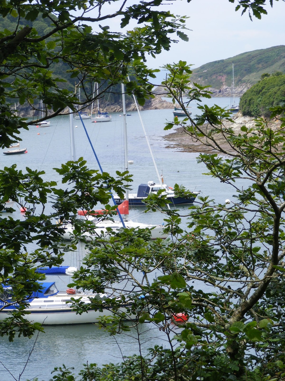
This is an easy  part of the south west coast path, with beautiful views and a fairly flat path.  Once we reached the mouth of the River Yealm we also had sight of the yahts.  After walking up the river Yealm we came to some benches so we stopped for our lunch, with a beautiful view.


We continued walking on to Noss Mayo and then walked up the hill past the tennis courts.  This road became a track and ended up, after a long upward climb by the entrance to the car park.  This was the only hill on the walk.

This 4.5 mile walk is described at  http://www.southwestcoastpath.com/walksdb/91/

Thursday, 12 January 2012

Looe to Mildrendreath

We caught the train to Looe, a very pleasant train ride with beautiful views out of the carriage all the way. As we approached Looe there were many birds in the river - herons, egrets, curlews as well as gulls and ducks.

After walking around Looe and having some lunch we followed the South West Coast Path towards Mildenreath.  There was a long steep climb up from Looe town, but the view from the top of the cliff over the beach to Hannafore Point was worth the effort.


We continued walking around the coast.  There was a proper path all the way, and we were often on quiet roads between attractive houses.  After we had gone down to Plaidy Beach we had to go up another hill and then down a long hill with steps to Mildrendeath.


We then turned around and walked back to Looe.  It had been an ideal walk for a winter's day when other paths would have been muddy.

Friday, 30 September 2011

Whitsand Bay Part 2

In the past we have walked around Whitsand Bay from Rame Head to the Cliff Top cafe  and from Tregantle Fort to Portwrinkle.   So we can say we have done all the South West Coast Path we decided to walk from Tregantle Fort to the Cliff Top cafe.

The walk from Tregantle Fort was easier than walking from the other end of  Whitsand Bay.  There were no steep ups and downs just gentle slopes.  However, after a time we had to walk along the road, which was not too busy, but nevertheless not as good as being off road.

Godrevy Head to Hell's Mouth

Our holiday finished today, but we determined to make the best of the time left.  We started by driving to Godrevy Head.  This is a special place.  To one side there is the wide sweep of sand of St Ives Bay, with the surfers at Gwithian.  Out to sea there is Godrevy Island with the lighthouse standing bright and proud.


As we walked around the other side of the headland we saw a seal bobbing up and down in the sea.  We looked down at the next cove and there were a number of seas on the stones.  They were well camaflouged against the grey stones but you cold see them moving towards the sea.  At one point I counted a group of about a dozen going into the water.


We continued walking around the coastal path admiring the views until we reached Hell's Mouth, which we had walked to on Friday.  This was not so spectacular today as it was low tide.  We stopped for a coffee at the cafe there - very good before walking back to Godrevy and seeing more seals.

West Cornwall Holiday

We started today by driving to Long Rock, between Penzance and Marazion, to the free car park we found the last time we were in the area.  From there we walked along the edge of the beach towards St Michael's Mount.  The tide was out so we were able to walk across to the Mount.  However it was too early to go into the castle and gardens.

As we walked back to the car I decided to stay by the waters edge.  The tide was coming in and already the water was coming into the harbour on St Michael's Mount.


There were quite a few birds feeding at the edge of the sea.  This one group seemed to be a young family.  They were like little children running in and out of the waves.


From Penzance we drove to Sennen Cove.  We parked at the beach car park and walked towards the harbour.  We should have parked at the harbour car park as it was cheaper!  From the harbour we climbed steps up to the cliff and then walked towards Lands End.


After walking round Lands End and photographing the iconic signpost we headed back to Sennen Cove.


 After watching the surfers at Sennen beach we drove to Porthcurno.  The beach there had beautiful fine sand and the light yellow contrasted with the blue of the sea.

We walked across the beach and up steps to the Minack Theatre.  We saw that there was a steep flight of steps but thought we would manage that.  however when we reached the top there was more!  The steps were uneven, with no handrail and carved in the side of the cliff.  It was very scary!  There was no way we were going to go down so we had to keep going up.  However, when we looked along the coast the view was lovely.  Eventually, with signs of relief, with reached the top.  However, because there was a performance going on we were not able to go into the Minack Theatre.  Instead we walked down the road back to the car park.  The road was narrow and bendy, but not as bad as the steps!

St Ives

While staying at Hayle we drove to Carbis Bay to catch the train to St Ives  The station is right on the coast by Porthminster Beach

The train that took us to St Ives

We walked around the coast from Porthminster Beach past the harbour and across the Island to Porthmeor Beach.  This was an evening walk, but unfortunately there was no spectacular sunset although the light was still good.

St Ives Harbour

The Island, St Ives

Monday, 26 September 2011

Newquay and North Cliffs

On Friday 23 September for the first time we visited Newquay.  We stopped on the road just by the Western Beach and had our coffee on the cliff top watching people learn to surf.  We then walked through this end of the town seeing what shops were there before our hour had run out and we had to move the car.  We then drove on to the other end of the town and after parking near Towan Beach we walked along the coast past the harbour around the headland to Fistral Beach.


We then walked back and ate our lunch in the gardens overlooking the island.


We then moved on towards Hayle.  We stopped again just past Portreath at North Cliffs and walked along the coast to Hells Mouth.  This is a very easy part of the south west coast path, a good path and no steep slopes.  Reskajeage Downs was covered in heather, but unfortunately most of it had finished flowering.  It must have looked spectacular a week or two ago.  However, the sea views were lovely.


Hell's Mouth

Thursday, 22 September 2011

Warren Point to Stoke Beach

Yesterday the sun was shining so we decided to join up two walks we had done previously.  We drove to the National Trust car park just outside Noss Mayo (Should have turned right just at the Noss Mayo sign).  Probably won't use that car park again - very narrow road to reach it - the next car park along at Stoke Point is easier to access.

There was a steep walk down the side of the field to the coast path, but the coast path was a broad firm path and it was easy walking.  There were no steep sections in this walk.  The sea was dark blue and the foam on the top of the waves contrasted sharply to it as they hit the black rocks.


When we left this broad path to walk through woodland near Stoke Beach the path was muddier, and as we have found in the past there were lots of butterflies around, particularly red admirals.


The leaves had not started to change colour yet, but there were signs of autumn around, such as the chestnuts that were beginning to fall.


Monday, 5 September 2011

Perranporth


The sun was shining when we left Plymouth, but the forecast was for showers.  When we arrived it was sunny but windy.  We drank our coffee sat in the car looking out on to the beach.  It was high tide and the surf was up, but the waves were not  as large as had been forecast.

We started to walk westward towards St Agnes.  From the cliff top we had a great view across the bay.


The waves were crashing against the rocks further along the cliff.


The heather was just beginning to come out which made the scenery even more beautiful.


It was so windy we did not fancy walking on the cliff edge so we headed inland on a path, this lead to a disused mining work and the path disappeared.  After sheltering while a shower went through we walked back to the coast and followed the coast path back to Perranporth.


After lunch we walked along the beach.  The tide was still in so we could not walk around the rocks but had to climb up the sand dunes.  We continued through the dunes until we came to Perran Sands where there was a concrete path down to the beach.


We walked all the way along the sand to the end (Ligger Point).  We then turned around and came back.  Because the tide had gone out we were able to stay on the beach all the way back to our car.

Saturday, 27 August 2011

Tregantle Fort

Another showery day, so we decided not to go too far in case it rained and we were not able to walk.  As it was still August we were able to walk across the firing range in front of Tregantle Fort instead of taking the other path along the road.  As the weather was not that good we were able to park by the gate to the firing range.

Initially we walked down to the beach.  It was nearing high tide so we could not walk far along the beach and it was too windy to sit and watch those brave enough to go in the sea. Kite surfers were doing the best in the conditions.


We then climbed back to the top and followed the path through the firing range in front of the fort.  Once we came to the other path we continue to walk in a westerly direction for a while.  The views in both directions were wonderful, although the would have been even better if it had been a sunny day.  Dark clouds were gathering so we decided we had chanced the weather long enough so we turned back.
The view westward

The view eastward

Whitsand Bay

A pleasant, easy walk.  It would probably have been even more spectacular at low tide when you could see more of the beaches at Whitsand Bay.

Sunday, 21 August 2011

Stoke Point


Having parked the car at the National Trust car park inland from Stoke Point we walked down to the coastal path.  This was a very steep path and we determined to find another way back to the car!  We headed eastward and there were beautiful views out to sea and along the coast to Bigbury and beyond.


The path was wide and good and after a while went through woods with plenty of butterflies around.  The path was fairly flat and we slowly went down to the edge of Stoke Beach and then gradually walked up towards Beacon Hill.  We then came to a steep path downwards.  There a path inland that looked as if would skirt this steep hill, but we did not have a map with us so we decided to turn round at this point.

When we came to the pathway back to the carpark we chose to walk on further to the next point and then cut up the hill gradually back to the car park.  A much better way than the downward path.

Tuesday, 9 August 2011

Rame Head

This morning we drove to the car park on Rame Head next to the coastguard station.  From here you could see both up and down the coast and visibility was so good the Eddystone Lighthouse looked quite close!  We followed the coastal path towards Whitsand Bay and the views were spectacular.  Near Polhawn Fort there was a hedge full of wild flowers, making the view down the coast even more attractive.


When we reached the coast road we left the coastal path intending to cut across country to Kingsand to do a circular walk around Rame Head.  The walk instructions told us to continue down a road and then take a path to the left.  We walked quite along way until we came to a left turn and when we walked up there we realised we had come to far and were going in the wrong direction.  We retraced our steps, went across a couple of fields and came back onto our original path where we followed our instincts and went down a footpath on the right.  This turned out to be correct and we were soon walking down to Kingsand, with a view of Plymouth Sound and breakwater.


After stopping in Cawsand for lunch, watching sailors and children enjoying the sea, we climbed up the coastal path along Rame Head.  The view out to sea was obscured by trees most of the time, but we had tantalisingly beautiful glimpses at time with yahts with white sails contrasting with the sparkling blue sea.  I would like to repeat this walk when the trees were not in leaf as I am sure it would be glorious.


At one point we heard rustling in the trees beside us and just caught sight of a fawn running through the woodland.

When we arrived back at the tip of Rame Head we  went out to the derelict chapel on the edge of  headland, from where you could see in all directions.

Saturday, 2 July 2011

Torquay to Brixham

We caught the train to Torquay and it was just a stone's throw from the station to Torquay beach.  This is where we stopped walking earlier in the year when we walked from Torquay to Meadfoot Beach. We followed the road  towards Paignton and for a short while had to walk on the pavement by the main road. Although it is not pleasant to have cars rushing past you, before long we had views over the sea, and this made up for it.  Soon able to turn off to go through a park at Hollicombe, and from then on we were off-road the whole of the way.

We did not see the sign for the SW coast path and continued walking down to Hollicombe beach.  It was low tide and we saw that other people were walking across the rocks to the beach beyond, so we decided to follow them.  To begin with it was easy as the rocks were flat and encrusted with barnicles so there was plenty of grip.  However, near Preston Sands there was no alternative but to walk across seaweed covered rocks and through shallow pools, but we made it to the other side.   With the tide out we were then able to walk all the way to the end of Paignton Sands without having to go up to the road.

We walked around the harbour and then through the park down to Goodrington.  The views on this walk were spectacular with long views around the bay and beautiful beaches and covers.  Photos cannot capture this.


Goodrington

Up to this point the walk had been easy but from now on there were many ups and downs, with rough steps, but the views were worth it.  Broad Sands was a lovely beach that I had never been to before.  After Elberry Cove we walked through woodland that was pleasantly cool, although the path had roots and stones sticking out of it which meant you had to watch your feet.  We could see the blue of the sea through the trees but there was no view of the bay with all the leaves on the trees.

As we walked down to Churston Cove we were struck by how lovely it looked with all the boats and Brixham in the distance, although the beach itself was not very attractive as stony.


After climbing up from this cove it was just a short walk on to Brixham.  We could look back and see Torquay with its balloon and realise how far we had walked (about 6 1/2 miles).  We were glad that there was a frequent bus service from Brixham to Torquay so we did not have to walk back!

Wednesday, 29 June 2011

Seaton to Downderry

It was a lovely sunny morning.  I had an appointment at lunchtime, but we decided to make the most of the morning and go to Seaton.  It only took 35 minutes to drive there and we were able to park on the road facing the beach - a lovely spot for morning coffee.

View from Seaton beach across to Looe
We then walked along the sea wall towards Downderry.  Since we were last here they have build a set a steps at the end of the sea wall, so you don't have to clamber over rocks now.  We continued walking along the beach till we came to Downderry, then turned round and walked all the way back to Seaton along the beach.  A very pleasant 30 minute walk.

Monday, 6 June 2011

East Portlemouth to Gara Rock

We drove to Salcombe and parked the car in the road leading down to North Sands.  It was nearly high tide so not much beach, but it was still a pleasant view as we had our morning coffee.

We walked from there to the ferry steps where we took the ferry to East Portlemouth.  As the tide was in we walked along the road to Mill Bay and then followed the path through woodlands along the edge of the estuary, occasionally getting views across to Salcombe and the yachts sailing up and down the estuary.   The water was a beautiful azure blue.

Looking across to South Sands

The path followed the coast around and we could see round to Hope Cove and beyond.  The path was narrow and steep at times, but there were no long hills to climb and the views were worth the effort.

Looking down the coast

We eventually came to Garra Rock.  But there was no hotel there, just a building site where they were building expensive looking apartments.  At this point we walked inland and then made our way back through woodlands to Mill Bay.  It was a good path and a shorter way back, but we missed the spectacular sea views.

We stopped at Mill Bay for a late lunch - all the benches along the way had been occupied by other walkers taking a rest!  The tide had now gone out sufficiently for us to walk back to East Portlemouth along the beach.

Having taken the ferry back to Salcombe we walked into the town and had tea at our favourite cafe overlooking the harbour.  Then we walked back to North Sands seeing where we had walked on the other side of the estuary.

Looking across to East Portlemouth